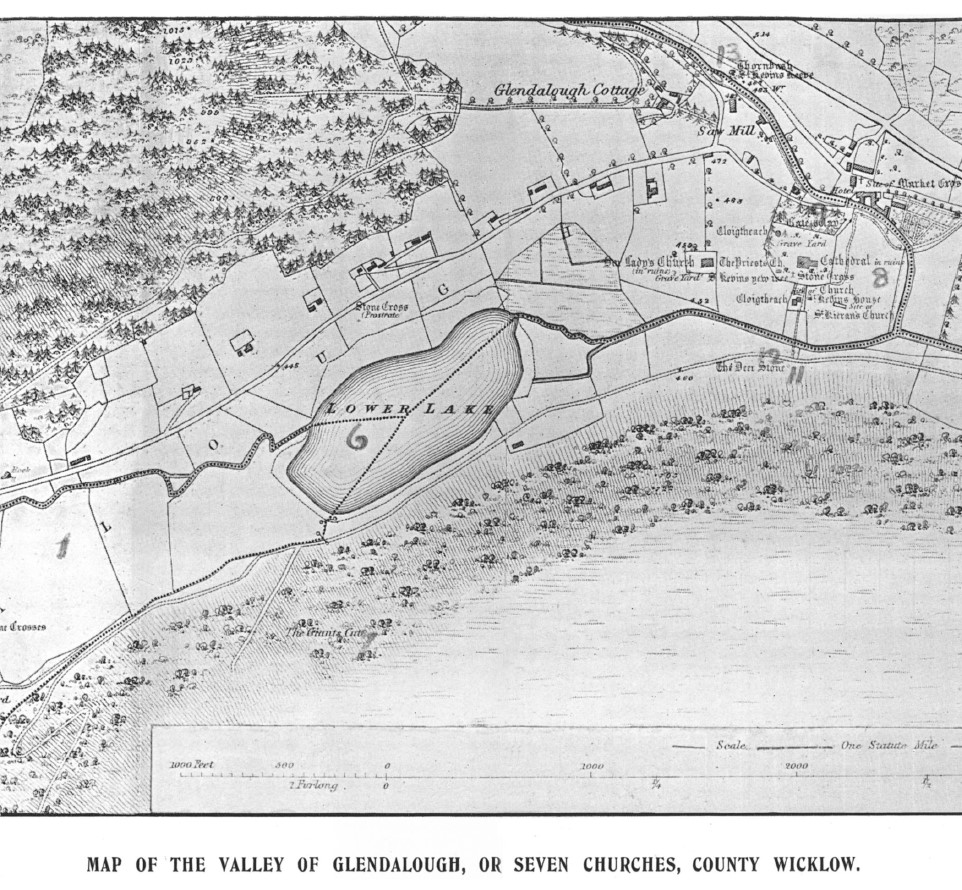
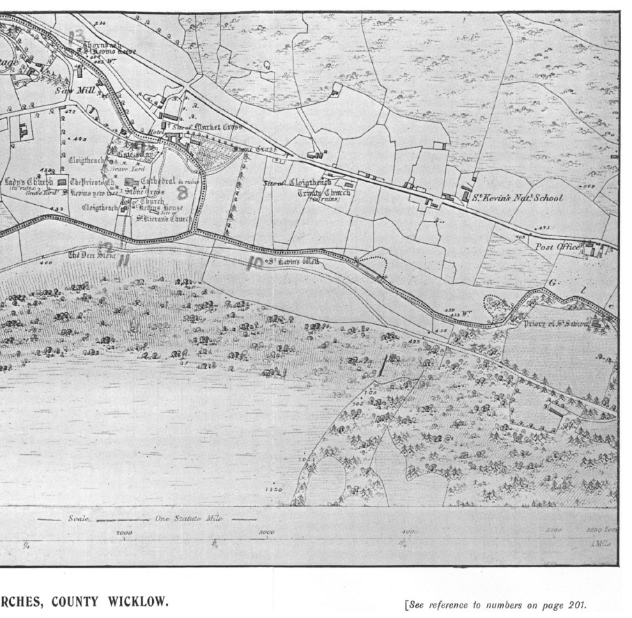
Place-names at the Seven Churches, Glendalough, Co. Wicklow (published in 1906)


")


Original article published in: The Journal of the Royal Society of Antiquaries of Ireland, Fifth Series, Vol. 36,No. 2, [Fifth Series, Vol. 16] (Jun. 30, 1906), pp. 198-201
When visiting these ruins during the spring of 1904, from inquiries I then made, I found a few local names which are not marked on the six-inch Ordnance Survey Sheet of this district.
The name of the stretch of land lying between the two loughs is called “the Eeshert.” This name I take to be a corruption of the Irish word Bisert, meaning, according to Dr. Joyce’s “Irish Names of Places Explained” (First Series, p. 324), ‘a wilderness, a sequestered place, or hermitage.’ This word also appears in corrupt forms, commencing names of places, as “Ester,” “Ister,” “Issert,” “Desert,” and “Dysart.”
Close to, and just above, the Reefert Church is a well reputed holy, known as ” the Eeshert Well,” which is resorted to for the cure of internal pains and diarrhoea; it is now in a neglected condition, and, when I saw it, was partially covered by a large mountain-ash blown down in the storm of February, 1903.
As the Reefert Church is practically on “the Eeshert,” one would expect “Dysert-kevin” to be another name for it, and not for the Templenaskellig Church (near St. Kevin’s Bed), as the Ordnance Survey Map has it so marked down.
To the west of the Reefert Church, and a little higher up the mountain side, is what is called ” St. Kevin’s Cell”; it consists of a low circular wall, built of loose stones, which surrounds a small rude stone cross. The legend of the blackbird laying her eggs and hatching them in St. Kevin’s out-stretched hand, is associated with this spot.
The ‘Lower Lake’ is also known as ” Lough-na-Peestha,” i.e. ‘the lake of the serpent.’ It is said to have obtained that name from a water-monster which inhabited it, and which at night-time threw down the church walls erected by St. Kevin during the day, till eventually the saint lay in wait for it one night, and, cutting off its retreat to the lough, worried it to death with the help of his wolf-hound ” Loopah.”
“The Giant’s Cut,” marked on the map on the side of Derrybawn mountain, is attributed to a “lick” dealt by Finn Mac Coole with his sword, to test its quality.
The point of land between the Cathedral burial-ground and the junction of the Glendalough and Glendasan streams (which form the Avonmore river) bears the name “Monteoge.”
The, now planted, paddock on the north side of the Cathedral burial ground was “the pattern-field.” Here were pitched the booths and tents during the week of the pattern, which commenced on the Sunday previous to St. Kevin’s Day (the 3rd of June). The pattern was suppressed by the clergy some thirty-five years ago; and St. Kevin’s Well, which is situated on the far side of the Avonmore river, opposite to the Trinity Church, is now in a sadly neglected condition.
Strange to say, the oldest headstone in the Cathedral burial-ground does not date back earlier than the year 1717; it stands to the south west of the cathedral, and bears the following short inscription :-
Here lieth ye Body of Dudley Costolo, Deceased August ye 14th 1717.
With a solitary exception, no interments have been made within the last few centuries at any of the Seven Churches, apart from the Cathedral burial-ground. The one exception consists of a couple of graves which lie at the east end of the St. Saviour’s Priory enclosure. Here were interred two brothers, strangers in the locality, who were hanged for highway robbery on the 26th April, 1765 ; as the headstones inform one, they were named Michael and Joseph Meagan (? Magan or McCann).
The Ordnance Survey Map has marked on it, near the foot-bridge over the Glendalough stream at the end of the Cathedral enclosure, the Deer Stone. This consists of a granite boulder, with an artificial hollow in it. It obtained its name, according to the legend, at the time St. Kevin was engaged erecting the churches. A mason of his had just lost his wife in giving birth to twins ; and St. Kevin, being at his wits’ end to know how he was to obtain milk to feed them on, as was his wont, resorted to prayer; while so occupied, a wild doe came down from the heights of Derrybawn mountain, and approaching this bullaun-stone poured her milk into it; this she did morning and evening until the twins were weaned. Hence the name.
There is said to be a cure obtained from the water lodged in the hollow in ” the Deer Stone”; but to be effective, it should be visited fasting before sunrise on a Sunday, Tuesday, and Thursday in the same week, and on each occasion a part of the ceremony is to crawl round it seven times on the bare knees with the necessary prayers.
On the long granite boulder by the side of ” the Deer Stone ” are pointed out the print of St. Kevin’s hand and the impress of the calf of his leg ; this is ” St. Kevin’s chair.”
A perch or two to the west on the left-hand side of ‘the Green road’ is an artificially fashioned tub-like granite stone known as ” St. Kevin’s Griddle ” ; and near it, on the opposite side of the track, is another bullaun-stone, about which I could get no information.
On the Glendasan stream (which is separated from the Glendalough stream by the Kaymaderry mountain), nearly opposite to the saw-mill, is a spot marked on the Ordnance Survey Map, St. Kevin’s Keeve and Thornbush. The Keeve is situated just below a small, rocky cataract, under the northern bank of the stream; in appearance it resembles a small well in the rock, and is still resorted to for cures.
An ancient Skeoch, or white-thorn, formerly stood above the Keeve, and its branches used to be laden with rags tied to them; a storm, however, blew it down a few years ago, and its decayed stump alone now remains.
A legend relates how on one occasion while St. Kevin was bathing in the pool near the Keeve, a woman carrying five loaves of bread in her shawl passed along. St. Kevin, with only his head above the water, bade her the time of day, and inquired what her load was. “It’s stones I’m carrying,” she replied. “Musha then,” said the Saint, ” if it’s stones they are, that they may be bread; and if it’s bread, that they may be stones.” The woman proceeded on, and presently the weight of her load caused her to rest, and on placing the bread on the road-side she discovered that it had been turned into five loaf-like stones.
In recent years the stone loaves, which lay near the Royal Hotel, have disappeared; they were broken up and carried off by tourists. The name Kevin is correctly pronounced Kavin, as in Kavanagh.
References to Map of Glendalough.
1. The Eeshert.
2. The Eeshert Well.
3. The Reefert Church.
4. Templenaskellig, or (?) Dysartkevin.
5. St. Kevin’s Cell.
6. Lough-na-Peestha.
7. The Giant’s Cut.
8. Monteoge.
9. The Pattern Field.
10. St. Kevin’s Well.
11. The Deer Stone and St. Kevin’s Chair
12. St. Kevin’s Griddle.
13. St. Kevin’s Keeve and Bush.
Reproduced with the kind permission of the Royal Society of Antiquaries of Ireland.
Original article in: The Journal of the Royal Society of Antiquaries of Ireland, Fifth Series, Vol. 36,No. 2, [Fifth Series, Vol. 16] (Jun. 30, 1906), pp. 198-201


No Comments
Add a comment about this page