In 2018, the Glendalough Heritage Forum presented an exhibition of maps of Ireland, all of which featured Glendalough. The exhibition took place in the Brockagh Centre, Glendalough during Heritage Week and can still be viewed in the centre.

This article displays a series of snips from the maps featured in this exhibition, charting the development of the name of the valley and how it was referred to historically.
It also charts how mapping systems and technology have developed through representations of Glendalough over five centuries up to the modern day.
The maps featured in the exhibition cover the full range of mapping as we now understand it – with all types of maps, from manuscript to jpegs, from geophysical to geophysics, from ordnance survey to satellite and lidar imagery.

Hiberniae Britanicae Insulae Nova Descriptio Eryn: Drawn by Matthias Quad (1557-1613). This map was published in 1600 in Cologne and is an early document denoting Glandalag. The word OTOLA is written beneath, indicating O’Toole country. Courtesy of the Rumsey Map Collection.

Irlandiae Accurata Descriptio: Drawn by Abraham Orteius (1527-1598) and Jan Baptista Vrients and published in Antwerp in 1608, it is based on an earlier work by Baptista Boazio. It refers to Glendalough as XI Churches which is possibly more accurate than its famous name of ‘Seven Churches’. Courtesy of the Rumsey Map Collection.

Irlande ou Hibernie: Drawn by Philip Briet (1601-1668) and published in 1648 by Sebastiani and Gabriellis Cramoisy in Paris. One of numerous maps of the period that refer to the religious settlement as Glandeloure. Courtesy of the Rumsey Map Collection.

Novissima prae caeteris aliis accuratissima Regnorum Angliae, Scotiae, Hiberniae: A map by Frederick de Wit (1629 – 1706) dated 1682 and published in Amsterdam. An early reference to ‘7 Churches’. Courtesy of the Rumsey Map Collection.

Les Isles Britaniques ou sont les Royaumes d’Angleterre, d’Escosse et d’Irlande: Drawn by Nicolas de Fer (1646-1720) in 1705 and published by Chez l’Auteur in Paris. Referred to once again as Glandeloure, the surrounding town names hint at the importance of the settlement at this time. Courtesy of the Rumsey Map Collection.

Les Isles Britanique: Another Nicolas de Fer (1646-1720) map, this one published in French in Paris in 1706, it refers to ‘Les Churches’ (the churches) and interestingly has eight church points spatially represented. Courtesy of the Rumsey Map Collection.

Royaume D’Irlande: Drawn by Alexis Hubert Jaillot (1632-1712), based on the work of Nicolas Sanson (1600-1667) and published in Amsterdam and Paris in 1708. Seven Churches is the name of the settlement in this map and again we see icons representing each church. Courtesy of the Rumsey Map Collection.

Ireland: A map by Herman Moll (1654-1732) published by John and Tho. Bowles of Cornhill in 1714. Refers to The 7 Churches at Glandelogh pictorially using church icons. Courtesy of the Rumsey Map Collection.

Regnum Hiberniae: Drawn by Matthaeus Seutter (1678-1756). Self-published in 1755 in Augsburg, this map refers to 7 churches and is shown as a little line of church buildings. Courtesy of the Rumsey Map Collection.

A New and Accurate Map of the Kingdom of Ireland: Drawn by Thomas Jeffreys (1719-1771) and published in London and La Haye (The Hague) in 1759. The notation for Glendalough is ‘the 7 Churches or Glandelogh’ directly noting the two names for the monastic settlement. Church buildings are represented by a wonderfully symmetrical circle cluster. Courtesy of the Rumsey Map Collection.

A map of the Kingdom of Ireland, divided into provinces, counties and baronies…: John Rocque’s (1709-1762) map published in 1790 by Robert Sayer of London. Refers to The 7 Churches at Glandelogh and this map notes the proximity of the lakes to the settlement. Courtesy of the Rumsey Map Collection.

Ireland: Drawn and published in London by Aaron Arrowsmith (1750-1823) in 1811. This map shows both Seven Churches and Glandalough La. (lake) and depicts other mountain and valley features. Courtesy of the Rumsey Map Collection.

Britisches Reich. C. Kon: Ireland. a. Prov: Leinster: By William Ernst August von Schlieben (1781-1839) and published in Leipzig in 1830, this map of Leinster sees the introduction of the letter ‘e’ into the name of the monastic settlement at ‘Glendulogh’. Courtesy of the Rumsey Map Collection.

Ireland. Published by D. Lizars, Edinburgh: Drawn by Daniel Lizars (1760-1812) and published posthumously in Dublin and Edinburgh in 1831, this map notes both the monastic Glandalough and Lake Glandalough. Courtesy of the Rumsey Map Collection.
![]()
Ireland: John Arrowsmith’s (1790-1873) map, published in London in 1832, importantly refers to the 7 Churches, Glendalogh and the Lead mines that were so important to the later economic development of the valley. Courtesy of the Rumsey Map Collection.

Ireland (south sheet): Created by the Society for the Diffusion of Useful Knowledge (Great Britain) and published in London in 1838, this map uses the modern spelling of the monastic settlement, referring to the 7 Churches of Glendalough. There is also note made of Lara Br. (bridge). Courtesy of the Rumsey Map Collection.

Ireland: By R.M. Martin and J. & F. Tallis and published in New York in 1851. This map does not depict Glendalough but is notable for a beautiful illustration along the East coast that likely represents the ruins at Glendalough. Courtesy of the Rumsey Map Collection.
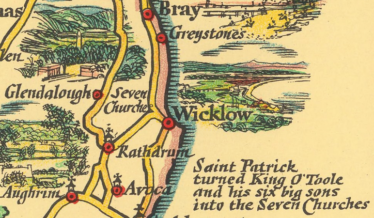
Pratts High Test Plan of Ireland: A map by Alfred Taylor and S.P.B. Pratt, published by the Anglo-American Oil Co. Ltd. in Dublin in 1933, this map contains a wonderful anecdote concerning the Seven Churches in its margins. Courtesy of the Rumsey Map Collection.

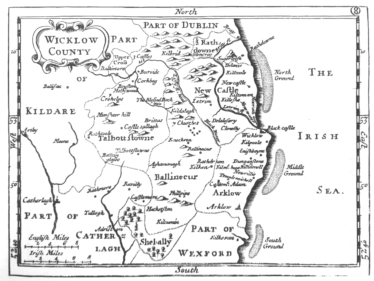
A Plan of Glendaloch and the Seven Churches in the County of Wicklow: Attributed to ‘unknown artist’ but almost certainly Gabriel Beranger and Angelo Bigari’s 1791 map of Glendalough. Map is oriented South to North so appears ‘upside-down’ in our modern reading. Courtesy of the National Library of Ireland.

Glendalough and the Seven Churches: Drawn by John Bartholomew of Edinburgh and published in 1891, this map is based heavily on the Ordnance Survey’s first edition mapping. From private collection.

Glendalough – A map of the Monuments: This Map appeared in the Commissioner of Public Work’s guide book for Glendalough written by H. G. Leask and first published in 1955. Courtesy of the Office of Public Works.

Glendalough LiDAR: This LiDAR map of the Glendalough Valley was created in 2017 to map the tree coverage type and extents in the greater valley region. The LiDAR coverage appears only for forested areas. Courtesy of Coillte.

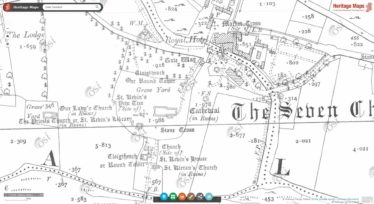
Ordnance Survey First Edition Map on HeritageMaps.ie: The Ordnance Survey First Edition map of Glendalough published on 29th of April 1840 is here displayed on the Heritage Council’s map viewer HeritageMaps.ie. Courtesy of Ordnance Survey Ireland and the Heritage Council

Ortho 2005: Aerial Imagery of Glendalough from the Wicklow Gap fork to the Miner’s Village switchbacks, this image was captured in 2005 and is now one of numerous aerial images of the valley available online. Courtesy of HeritageMaps.ie and Ordnance Survey Ireland

Processed 2011–12 Fluxgate Gradiometer data showing results of surveys around the main monastic complex, Our Lady’s Church and Seven Fonts: Published in 2014 by UCD’s School of Archaeology, this map displays magnetometer survey results for the graveyard complex surrounds. Overlain on OSi 2nd Edition map published June 1st 1910. Courtesy of UCD School of Archaeology and Ordnance Survey Ireland.

Interpretative plan of the 2011-12 geophysical surveys showing suggested archaeological features: Published in 2014 by UCD’s School of Archaeology, this map displays interprets several geo-physical survey results for the graveyard complex surrounds. Overlain on OSi 2nd Edition map published June 1st 1910. Courtesy of UCD School of Archaeology and Ordnance Survey Ireland.

Glendalough Graveyard Trail: Published in 2017 by the Glendalough Heritage Forum, this map by Aoife Patterson marks out graves of particular historical interest in the Monastic Complex. Courtesy of the Glendalough Heritage Forum.
Glendalough Graveyard Trail: Published in 2017 by the Glendalough Heritage Forum, this map by Aoife Patterson marks out graves of particular historical interest in the Monastic Complex. Courtesy of the Glendalough Heritage Forum.
Ordnance Survey Second Edition Map on HeritageMaps.ie: The Ordnance Survey Second Edition map of Glendalough published on 1st of June 1910 is here displayed on the Heritage Council’s map viewer HeritageMaps.ie. Courtesy of Ordnance Survey Ireland and the Heritage Council.


No Comments
Add a comment about this page